Residential land supply and development Broadhectare study

Queensland Government Statistician’s Office’s broadhectare study identifies the location and quantifies the area, timing of development, and dwelling yield of larger land parcels to house a specified region’s growing population. Each study involves consultation and collaboration with local government, the Urban Development Institute of Australia (Queensland) and major developers.
Broadhectare studies for South East Queensland and other regions throughout Queensland are available to download from this page. The PDF reports include static maps as generated at the time of the study. For the latest information, broadhectare summary data are available from the Residential land development activity profiles. Alternatively, an interactive map of the broadhectare results can be accessed or the spatial layer can be downloaded from the Queensland Spatial Catalogue.
Broadhectare study methodology
The land identified in the broadhectare study is the first stage in the land development pipeline. It includes parcels of land identified as suitable and potentially available for future residential development. The study focuses on land parcels greater than 0.25 ha.
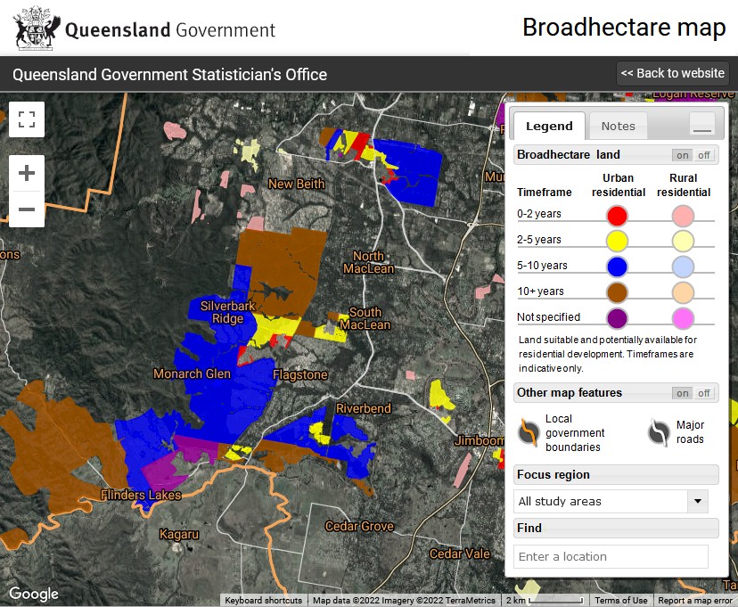
The identified residential land is categorised according to development potential as for either urban or rural residential use. The timing for land development is based on local government infrastructure extension programs, recent lot approvals and the development intentions of major developers. Timing is divided into the following five categories:
- 0–2 years
- 2+–5 years
- 5+–10 years
- 10+ years
- not specified.
The category ‘not specified’ also includes smaller parcels in existing developed areas where development occurs randomly (depending on the owners’ intentions).
The spatial analysis process utilised in the broadhectare study involves creating segments based on the Digital Cadastral Database (DCDB) over each local government area. Each segment is then updated with data that impact on the suitability and availability for residential development. Using rule-based filtering, broadhectare land stocks are identified.
Current Releases
Broadhectare map (data visualisation)
Queensland Government Statistician’s Office’s broadhectare study identifies the location and quantifies the area, timing of development, and dwelling yield of larger land parcels to house a specified region’s growing population. Each study involves consultation and collaboration with local government, the Urban Development Institute of Australia (Queensland) and major developers.
This data visualisation shows an interactive map of the current broadhectare results.
Broadhectare profiles, South East Queensland (report)
Broadhectare profiles for local government areas within South East Queensland Regional Planning Area are available to download from this page. Each PDF report includes a static map as generated at the time of the study.
Broadhectare profiles, North Queensland (report)
Broadhectare profiles for local government areas within North Queensland Regional Planning Area are available to download from this page. Each PDF report includes a static map as generated at the time of the study.
Broadhectare profiles, Mackay, Isaac and Whitsunday (report)
Broadhectare profiles for local government areas within Mackay, Isaac and Whitsunday Regional Planning Area are available to download from this page. Each PDF report includes a static map as generated at the time of the study.
Broadhectare profiles, Wide Bay-Burnett (report)
Broadhectare profiles for local government areas within Wide Bay-Burnett Regional Planning Area are available to download from this page. Each PDF report includes a static map as generated at the time of the study.
Broadhectare profiles, Far North Queensland (report)
Broadhectare profiles for local government areas within Far North Queensland Regional Planning Area are available to download from this page. Each PDF report includes a static map as generated at the time of the study. For the purposes of the broadhectare study, the Far North Queensland region excludes the Aboriginal Shires of Wujal Wujal and Yarrabah.
Broadhectare profiles, Central Queensland (report)
Broadhectare profiles for local government areas within Central Queensland Regional Planning Area are available to download from this page. Each PDF report includes a static map as generated at the time of the study.
Broadhectare profiles, Darling Downs (report)
Broadhectare profiles for local government areas within Darling Downs Regional Planning Area are available to download from this page. Each PDF report includes a static map as generated at the time of the study.

