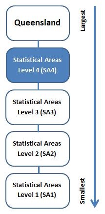
Statistical area level 4 (SA4) is one of the spatial units defined under the Australian Statistical Geography Standard (ASGS).
The ASGS is a hierarchical geographical classification, defined by the Australian Bureau of Statistics (ABS), which is used in the collection and dissemination of official statistics. The ASGS provides a common framework of statistical geography and thereby enables the production of statistics which are comparable and can be spatially integrated. This is the second edition of the ASGS, which updates the first edition (introduced in 2011).
The table below provides an all Queensland map and individual maps for each of the 19 SA4s within Queensland in a pdf format.
|
All Queensland
|
pdf (1.0 MB) |
|
Brisbane - East
|
pdf (1.9 MB) |
|
Brisbane Inner City
|
pdf (3.4 MB) |
|
Brisbane - North
|
pdf (4.1 MB) |
|
Brisbane - South
|
pdf (2.8 MB) |
|
Brisbane - West
|
pdf (2.6 MB) |
|
Cairns
|
pdf (1.7 MB) |
|
Central Queensland
|
pdf (2.4 MB) |
|
Darling Downs - Maranoa
|
pdf (2.1 MB) |
|
Gold Coast
|
pdf (2.1 MB) |
|
Ipswich
|
pdf (3.2 MB) |
|
Logan - Beaudesert
|
pdf (2.0 MB) |
|
Mackay - Isaac - Whitsunday
|
pdf (1.7 MB) |
|
Moreton Bay - North
|
pdf (2.9 MB) |
|
Moreton Bay - South
|
pdf (3.0 MB) |
|
Queensland - Outback
|
pdf (1.8 MB) |
|
Sunshine Coast
|
pdf (1.9 MB) |
|
Toowoomba
|
pdf (1.7 MB) |
|
Townsville
|
pdf (1.4 MB) |
|
Wide Bay
|
pdf (2.6 MB) |
Last reviewed

