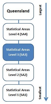
Statistical area level 3 (SA3) is one of the spatial units defined under the Australian Statistical Geography Standard (ASGS).
The ASGS is a hierarchical geographical classification, defined by the Australian Bureau of Statistics (ABS), which is used in the collection and dissemination of official statistics. The ASGS provides a common framework of statistical geography and thereby enables the production of statistics which are comparable and can be spatially integrated. This is the third edition (ASGS 2021), which updates the second edition (ASGS 2016).
The table below provides individual maps for each of the 82 SA3s within Queensland in a pdf format.
|
Bald Hills - Everton Park
|
pdf (1.9 MB) |
|
Beaudesert
|
pdf (1.0 MB) |
|
Beenleigh
|
pdf (1.5 MB) |
|
Biloela
|
pdf (1.1 MB) |
|
Bowen Basin - North
|
pdf (960 KB) |
|
Bribie - Beachmere
|
pdf (1.3 MB) |
|
Brisbane Inner
|
pdf (1.6 MB) |
|
Brisbane Inner - East
|
pdf (1.4 MB) |
|
Brisbane Inner - North
|
pdf (2.2 MB) |
|
Brisbane Inner - West
|
pdf (1.7 MB) |
|
Broadbeach - Burleigh
|
pdf (1.2 MB) |
|
Browns Plains
|
pdf (2.0 MB) |
|
Buderim
|
pdf (1.3 MB) |
|
Bundaberg
|
pdf (1.0 MB) |
|
Burnett
|
pdf (1.3 MB) |
|
Caboolture
|
pdf (1.3 MB) |
|
Caboolture Hinterland
|
pdf (1.3 MB) |
|
Cairns - North
|
pdf (1.0 MB) |
|
Cairns - South
|
pdf (1.0 MB) |
|
Caloundra
|
pdf (1.6 MB) |
|
Capalaba
|
pdf (1.5 MB) |
|
Carindale
|
pdf (2.1 MB) |
|
Centenary
|
pdf (1.4 MB) |
|
Central Highlands (Qld)
|
pdf (1.3 MB) |
|
Charters Towers - Ayr - Ingham
|
pdf (740 KB) |
|
Chermside
|
pdf (1.9 MB) |
|
Cleveland - Stradbroke
|
pdf (1.7 MB) |
|
Coolangatta
|
pdf (1.0 MB) |
|
Darling Downs - East
|
pdf (1.1 MB) |
|
Darling Downs (West) - Maranoa
|
pdf (1.1 MB) |
|
Far North
|
pdf (520 KB) |
|
Forest Lake - Oxley
|
pdf (2.3 MB) |
|
Gladstone
|
pdf (880 KB) |
|
Gold Coast Hinterland
|
pdf (1.3 MB) |
|
Gold Coast - North
|
pdf (2.0 MB) |
|
Granite Belt
|
pdf (1.5 MB) |
|
Gympie - Cooloola
|
pdf (1.5 MB) |
|
Hervey Bay
|
pdf (640 KB) |
|
Holland Park - Yeronga
|
pdf (2.4 MB) |
|
Innisfail - Cassowary Coast
|
pdf (960 KB) |
|
Ipswich Hinterland
|
pdf (1.9 MB) |
|
Ipswich Inner
|
pdf (1.7 MB) |
|
Jimboomba
|
pdf (1.7 MB) |
|
Kenmore - Brookfield - Moggill
|
pdf (2.0 MB) |
|
Loganlea - Carbrook
|
pdf (2.0 MB) |
|
Mackay
|
pdf (810 KB) |
|
Maroochy
|
pdf (940 KB) |
|
Maryborough
|
pdf (1.2 MB) |
|
Mt Gravatt
|
pdf (1.6 MB) |
|
Mudgeeraba - Tallebudgera
|
pdf (1.2 MB) |
|
Nambour
|
pdf (1.4 MB) |
|
Narangba - Burpengary
|
pdf (1.4 MB) |
|
Nathan
|
pdf (1.7 MB) |
|
Nerang
|
pdf (1.9 MB) |
|
Noosa
|
pdf (1.4 MB) |
|
Noosa Hinterland
|
pdf (1.5 MB) |
|
North Lakes
|
pdf (1.4 MB) |
|
Nundah
|
pdf (1.5 MB) |
|
Ormeau - Oxenford
|
pdf (1.7 MB) |
|
Outback - North
|
pdf (400 KB) |
|
Outback - South
|
pdf (380 KB) |
|
Port Douglas - Daintree
|
pdf (1.1 MB) |
|
Redcliffe
|
pdf (1.2 MB) |
|
Robina
|
pdf (1.8 MB) |
|
Rockhampton
|
pdf (900 KB) |
|
Rocklea - Acacia Ridge
|
pdf (1.9 MB) |
|
Sandgate
|
pdf (2.0 MB) |
|
Sherwood - Indooroopilly
|
pdf (1.9 MB) |
|
Southport
|
pdf (1.8 MB) |
|
Springfield - Redbank
|
pdf (1.6 MB) |
|
Springwood - Kingston
|
pdf (1.4 MB) |
|
Strathpine
|
pdf (2.3 MB) |
|
Sunnybank
|
pdf (1.6 MB) |
|
Sunshine Coast Hinterland
|
pdf (1.4 MB) |
|
Surfers Paradise
|
pdf (1.3 MB) |
|
Tablelands (East) - Kuranda
|
pdf (950 KB) |
|
The Gap - Enoggera
|
pdf (2.1 MB) |
|
The Hills District
|
pdf (1.9 MB) |
|
Toowoomba
|
pdf (1.2 MB) |
|
Townsville
|
pdf (780 KB) |
|
Whitsunday
|
pdf (840 KB) |
|
Wynnum - Manly
|
pdf (1.5 MB) |
Last reviewed

